
El Had topographic map
Interactive map
Click on the map to display elevation.
About this map
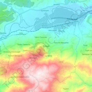
Name: El Had topographic map, elevation, terrain.
Location: El Had, Timezrit, Daïra Timezrit, Béjaïa, 06019, Algérie (36.57554 4.73397 36.65554 4.81397)
Average elevation: 405 m
Minimum elevation: 40 m
Maximum elevation: 1,127 m
Other topographic maps
Click on a map to view its topography, its elevation and its terrain.
Takhlicht
Algérie > Béjaïa > Daïra Timezrit > Timezrit
Takhlicht, Timezrit, Daïra Timezrit, Béjaïa, 06019, Algérie
Average elevation: 406 m