
Khetri topographic map
Interactive map
Click on the map to display elevation.
About this map
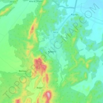
Name: Khetri topographic map, elevation, terrain.
Average elevation: 452 m
Minimum elevation: 353 m
Maximum elevation: 747 m
Khetri is located at 27°59′N 75°48′E / 27.98°N 75.8°E / 27.98; 75.8. It has an average elevation of 484 metres (1587 feet). The name of the mountain in Khetri is Bhopalgarh.
Other topographic maps
Click on a map to view its topography, its elevation and its terrain.
Barau
India > Rajasthan > Khetri Tehsil
Barau, Khetri Tehsil, Jhunjhunu District, Rajasthan, 333514, India
Average elevation: 427 m