Geolocate

Napo topographic map

Interactive map

Click on the map to display elevation.

About this map

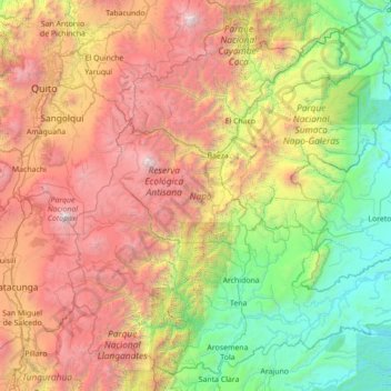
Name: Napo topographic map, elevation, terrain.

Location: Napo, Ecuador (-1.24869 -78.42726 0.03430 -77.02697)

Average elevation: 2,238 m

Minimum elevation: 284 m

Maximum elevation: 5,818 m

Other topographic maps

Click on a map to view its topography, its elevation and its terrain.

Conocoto

Ecuador > Pichincha > Quito Canton

Average elevation: 2,670 m

Zamora Chinchipe

Ecuador

Zamora Chinchipe (Spanish pronunciation: [saˈmoɾa tʃinˈtʃipe]), Province of Zamora Chinchipe is a province of the Republic of Ecuador, located at the southeastern end of the Amazon Basin, which shares borders with the Ecuadorian provinces of Azuay and Morona Santiago to the north, Loja and Azuay to the…

Average elevation: 1,548 m

San Salvador

Ecuador > Galápagos > Cantón Santa Cruz

The city is located in the Boquerón Volcano Valley, a region of high seismic activity. The city's average elevation is 659 meters (2,162 feet) above sea level, but ranges from a highest point of 1,186 meters (3,891 feet) above sea level to a lowest point of 596 m (1,955 ft) above sea level.

Average elevation: 81 m

Cotopaxi

Ecuador

Average elevation: 2,262 m

Pichincha

Ecuador

Average elevation: 2,503 m

Chimborazo

Ecuador

Average elevation: 2,664 m

Parroquia Caracol

Ecuador > Los Ríos > Babahoyo

Average elevation: 13 m

Juncal

Ecuador > Cañar > Cañar > Juncal

Average elevation: 3,018 m

San Lorenzo

Ecuador > Esmeraldas > San Lorenzo

Average elevation: 20 m

Carihuairazo

Ecuador > Tungurahua > Mocha

Average elevation: 4,572 m

Valdivia

Ecuador > Santa Elena Province > Valdivia

Average elevation: 19 m

Machachi

Ecuador > Pichincha > Machachi

Average elevation: 3,543 m

Guayas

Ecuador

Average elevation: 519 m

Atacazo

Ecuador > Pichincha > Lloa

Average elevation: 4,113 m