
Aïn El Hadjel topographic map
Interactive map
Click on the map to display elevation.
About this map
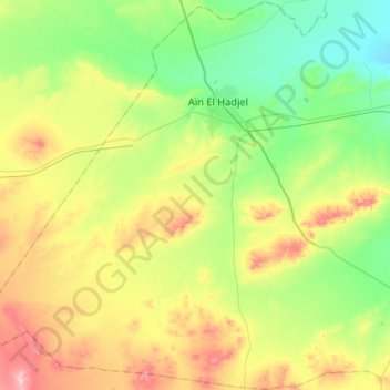
Name: Aïn El Hadjel topographic map, elevation, terrain.
Location: Aïn El Hadjel, Daïra Aïn El Hadjel, M'Sila, Algérie (35.50186 3.67740 35.73384 3.96431)
Average elevation: 599 m
Minimum elevation: 503 m
Maximum elevation: 770 m
Other topographic maps
Click on a map to view its topography, its elevation and its terrain.
Sidi Hadjeres
Algérie > M'Sila > Daïra Aïn El Hadjel > Sidi Hadjeres
Sidi Hadjeres, Daïra Aïn El Hadjel, M'Sila, Algérie
Average elevation: 563 m