
Thank you for supporting this site ❤️
Make a donation
Make a donation
Lewiston topographic map
Click on the map to display elevation.
Thank you for supporting this site ❤️
Make a donation
Make a donation
About this map
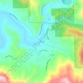
Name: Lewiston topographic map, elevation, terrain.
Location: Lewiston, Trinity County, California, 96052, United States (40.68737 -122.82752 40.72737 -122.78752)
Average elevation: 668 m
Minimum elevation: 537 m
Maximum elevation: 977 m
Thank you for supporting this site ❤️
Make a donation
Make a donation
Other topographic maps
Click on a map to view its topography, its elevation and its terrain.
Whiskeytown-Shasta-Trinity National Recreation Area - Trinity Unit
United States > California > Trinity County
Average elevation: 1,149 m
Thank you for supporting this site ❤️
Make a donation
Make a donation