
乌马河镇 topographic map
Interactive map
Click on the map to display elevation.
About this map
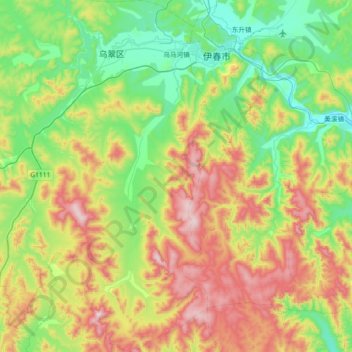
Name: 乌马河镇 topographic map, elevation, terrain.
Location: 乌马河镇, 乌翠区, 伊春区, 伊春市, 黑龙江省, 153000, 中国 (47.30500 128.58474 47.79803 128.97839)
Average elevation: 480 m
Minimum elevation: 205 m
Maximum elevation: 1,045 m
Other topographic maps
Click on a map to view its topography, its elevation and its terrain.