
Martaillac topographic map
Interactive map
Click on the map to display elevation.
About this map
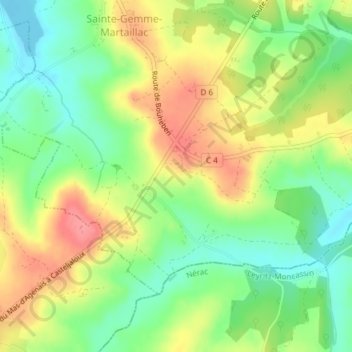
Name: Martaillac topographic map, elevation, terrain.
Average elevation: 114 m
Minimum elevation: 74 m
Maximum elevation: 161 m
Other topographic maps
Click on a map to view its topography, its elevation and its terrain.
Cougne
France > Nouvelle-Aquitaine > Lot-et-Garonne > Sainte-Gemme-Martaillac
Cougne, Sainte-Gemme-Martaillac, Marmande, Lot-et-Garonne, Nouvelle-Aquitaine, France métropolitaine, 47250, France
Average elevation: 112 m