
Thank you for supporting this site ❤️
Make a donation
Make a donation
Rehhorst topographic map
Click on the map to display elevation.
Thank you for supporting this site ❤️
Make a donation
Make a donation
About this map
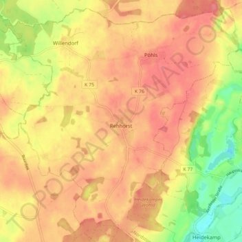
Name: Rehhorst topographic map, elevation, terrain.
Average elevation: 51 m
Minimum elevation: 5 m
Maximum elevation: 75 m
Thank you for supporting this site ❤️
Make a donation
Make a donation
Other topographic maps
Click on a map to view its topography, its elevation and its terrain.
Norddeutsches Tiefland
Deutschland > Schleswig-Holstein > Kreis Stormarn > Trittau
Das Euozeanische Klima prägt die Nordseeküste und die vorgelagerten Ostfriesischen Inseln und Nordfriesischen Inseln. Nach Süden schließt sich ein breiter Streifen ozeanisch (= atlantisch) bzw. subozeanisch geprägten Klimas an, der sich von der Ostküste Schleswig-Holsteins bis zu den westlichen…
Average elevation: 36 m
Thank you for supporting this site ❤️
Make a donation
Make a donation
Theodor-Wulff-Höhe
Deutschland > Schleswig-Holstein > Kreis Stormarn > Barsbüttel
Average elevation: 32 m
Thank you for supporting this site ❤️
Make a donation
Make a donation
Thank you for supporting this site ❤️
Make a donation
Make a donation