
Smyrna topographic map
Interactive map
Click on the map to display elevation.
About this map
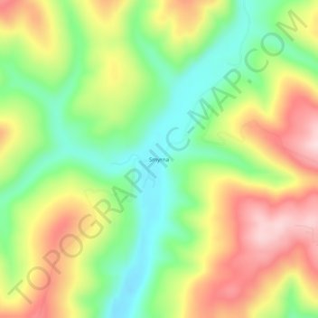
Name: Smyrna topographic map, elevation, terrain.
Location: Smyrna, Pope County, Arkansas, United States (35.63091 -92.93989 35.67091 -92.89989)
Average elevation: 402 m
Minimum elevation: 269 m
Maximum elevation: 562 m
Other topographic maps
Click on a map to view its topography, its elevation and its terrain.
Dover
United States > Arkansas > Pope County
Dover, Pope County, Arkansas, 72837, United States
Average elevation: 164 m
Russellville
United States > Arkansas > Pope County
Russellville, Pope County, Arkansas, United States
Average elevation: 133 m
Dover
United States > Arkansas > Pope County > Dover > Dover
Dover, Pope County, Arkansas, 72837, United States
Average elevation: 150 m
Moreland
United States > Arkansas > Pope County > Moreland
Moreland, Pope County, Arkansas, 72802:72837, United States
Average elevation: 236 m
Worthen
United States > Arkansas > Pope County > Pottsville
Worthen, Pottsville, Pope County, Arkansas, 72858, United States
Average elevation: 143 m