
Thank you for supporting this site ❤️
Make a donation
Make a donation
Karatay topographic map
Click on the map to display elevation.
Thank you for supporting this site ❤️
Make a donation
Make a donation
About this map
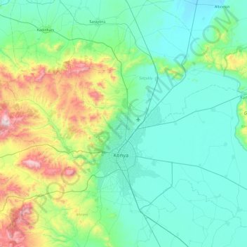
Name: Karatay topographic map, elevation, terrain.
Location: Karatay, Konya, Central Anatolia Region, Turkey (37.63957 32.49267 38.27596 33.42797)
Average elevation: 1,214 m
Minimum elevation: 965 m
Maximum elevation: 2,322 m
Thank you for supporting this site ❤️
Make a donation
Make a donation
Other topographic maps
Click on a map to view its topography, its elevation and its terrain.