
Thank you for supporting this site ❤️
Make a donation
Make a donation
Car Nicobar topographic map
Click on the map to display elevation.
Thank you for supporting this site ❤️
Make a donation
Make a donation
About this map
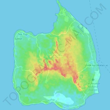
Name: Car Nicobar topographic map, elevation, terrain.
Location: Car Nicobar, Nicobar, Andaman and Nicobar Islands, India (9.11824 92.71865 9.25622 92.83093)
Average elevation: 11 m
Minimum elevation: -1 m
Maximum elevation: 67 m
Thank you for supporting this site ❤️
Make a donation
Make a donation