
Thank you for supporting this site ❤️
Make a donation
Make a donation
Kemnath topographic map
Click on the map to display elevation.
Thank you for supporting this site ❤️
Make a donation
Make a donation
About this map
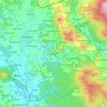
Name: Kemnath topographic map, elevation, terrain.
Average elevation: 531 m
Minimum elevation: 429 m
Maximum elevation: 836 m
Thank you for supporting this site ❤️
Make a donation
Make a donation
Other topographic maps
Click on a map to view its topography, its elevation and its terrain.
Thank you for supporting this site ❤️
Make a donation
Make a donation
Thank you for supporting this site ❤️
Make a donation
Make a donation
Thank you for supporting this site ❤️
Make a donation
Make a donation
Reuth bei Erbendorf
Deutschland > Bayern > Landkreis Tirschenreuth > Reuth b.Erbendorf
Average elevation: 488 m
Thank you for supporting this site ❤️
Make a donation
Make a donation
Thank you for supporting this site ❤️
Make a donation
Make a donation
Thank you for supporting this site ❤️
Make a donation
Make a donation
Thank you for supporting this site ❤️
Make a donation
Make a donation
Silberhütte
Deutschland > Bayern > Landkreis Tirschenreuth > Bärnau > Altglashütte
Average elevation: 766 m
Siegritz
Deutschland > Bayern > Landkreis Tirschenreuth > Erbendorf > Wetzldorf
Average elevation: 554 m
Thank you for supporting this site ❤️
Make a donation
Make a donation
Thank you for supporting this site ❤️
Make a donation
Make a donation