
Make a donation
Langenbach topographic map
Click on the map to display elevation.
Make a donation
About this map
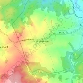
Name: Langenbach topographic map, elevation, terrain.
Average elevation: 523 m
Minimum elevation: 467 m
Maximum elevation: 597 m
Make a donation
Other topographic maps
Click on a map to view its topography, its elevation and its terrain.
Plauen
Deutschland > Sachsen > Vogtlandkreis
Die mittlere Höhe von 412 m ü. NN ist in Plauen ein sehr theoretischer Wert, denn der tiefste Punkt ist die Elstersohle mit 305 Metern (liegt im Ortsteil Röttis), der höchste Berg ist mit 525 Metern der bewaldete Culmberg (im südlichen Stadtteil Oberlosa). Hausberg von Plauen ist der 507 Meter hohe…
Average elevation: 429 m
Talsperre Pöhl
Deutschland > Sachsen > Vogtlandkreis > Helmsgrün
Die Talsperre Pöhl ist nach der Größe des Speicherraums die zweitgrößte und nach der Höhe des Absperrbauwerkes über Gründung sowie nach der Wasserfläche die drittgrößte Talsperre in Sachsen. Die Talsperre dient dem Hochwasserschutz, der Brauchwasserversorgung, der Niedrigwasseraufhöhung, der…
Average elevation: 388 m
Auerbach/Vogtland
Deutschland > Sachsen > Vogtlandkreis
Die Ortschaften Beerheide und Schnarrtanne sind staatlich anerkannte Erholungsorte. In Schnarrtanne bestanden zur DDR-Zeit das Ferienheim des Reichsbahnausbesserungswerks „7. Oktober“ Zwickau, das Betriebsferienlager „Rolf Weinbrecht“ und das Gardelko-Ferienheim in der im Jahr 2014 abgerissenen…
Average elevation: 586 m
Make a donation
Bad Elster
Deutschland > Sachsen > Vogtlandkreis
Bad Elster liegt im oberen Tal der Weißen Elster direkt an der Grenze zu Tschechien im Dreiländereck zwischen Böhmen, Bayern und Sachsen in der Nähe von Plauen und Hof. Der Ort ist von höheren waldreichen Bergen umgeben, die vor extremen Temperaturschwankungen schützen.
Average elevation: 562 m
Falkenstein/Vogtland
Deutschland > Sachsen > Vogtlandkreis
Geografisch liegt die Stadt im Osten des Naturraums Vogtland. Südöstlich der Stadt befindet sich die 1977 in Betrieb gegangene Talsperre Falkenstein. Falkenstein ist mit dem Auto 22 km von Reichenbach, 22 km von Plauen und 33 km von Zwickau entfernt. Das städtische Gebiet und die dazugehörenden Ortsteile…
Average elevation: 592 m
Klingenthal
Deutschland > Sachsen > Vogtlandkreis
Eine weitere bedeutende Veranstaltung ist Mundharmonika-Live an jedem dritten Wochenende im September. Höhepunkt des internationalen Mundharmonikafestivals ist neben den Workshops für Laien und Profis die musikalisch-kulinarische Livenacht mit Mundharmonikamusik in zahlreichen Klingenthaler Gaststätten. Die…
Average elevation: 734 m
Markneukirchen
Deutschland > Sachsen > Vogtlandkreis
Markneukirchen liegt als eine der südlichsten sächsischen Städte im oberen Vogtland. Beiderseits des Schwarzbaches, eines rechten Nebenflusses der Weißen Elster und dessen Nebentälern breiten sich die Stadt und ihre zugehörige Flur über die nördlichen und südlichen Bergrücken aus. Südlich der Stadt…
Average elevation: 583 m
Make a donation
Rodewisch
Deutschland > Sachsen > Vogtlandkreis
Rodewisch liegt im Tal der Göltzsch an den Einmündungen des Wernesbachs und der Pöltzsch auf einer Höhe von rund 450 m ü. NN. und damit im Osten des Vogtlandkreises in Südwestsachsen. Die Stadt liegt im sächsischen Teil des historischen Vogtlandes. Somit liegt Rodewisch im deutschen Mittelgebirgsraum in…
Average elevation: 490 m
Weiße Elster
Deutschland > Sachsen > Vogtlandkreis > Hundsgrün
Sie entspringt in Tschechien im Elstergebirge östlich von Aš (Asch), etwa einen Kilometer Luftlinie entfernt von der deutsch-tschechischen Grenze (westlich des Grenzsteines 5/18) bei Bärendorf, unweit des Dorfes Výhledy (Steingrün). Sie fließt durch die Städte Plauen, Gera sowie Leipzig und mündet im…
Average elevation: 468 m
Make a donation
Pausa-Mühltroff
Deutschland > Sachsen > Vogtlandkreis
Das Stadtgebiet besteht aus den zwei Hauptorten Pausa und Mühltroff, welche vormals eigene Städte waren, und neun umliegenden Dörfern. Mühltroff galt als westlichste Stadt Sachsens. Pausa, der Hauptort der Stadt Pausa-Mühltroff, befindet sich im östlichen Teil des Stadtgebiets auf einer Höhe von…
Average elevation: 477 m
Steinberg
Deutschland > Sachsen > Vogtlandkreis
Die Hauptattraktion und auch das namensgebende geographische Zentrum der Gemeinde ist der Steinberg mit einer Höhe von 659 Metern. Dort befindet sich neben dem 17,5 Meter hohen Aussichtsturm auch eine Gaststätte.
Average elevation: 576 m
Ellefeld
Deutschland > Sachsen > Vogtlandkreis
Die Höhenlage von Ellefeld beträgt 490 bis 650 Meter. Ellefeld liegt eingebettet in Wiesen und Wäldern am Flüsschen Göltzsch. Ellefeld liegt an der Bundesstraße 169 und wird von der Vogtlandbahn angefahren. Nördlich der Gemeinde liegt der Flugplatz Auerbach. Der Ort wird im vertakteten ÖPNV des…
Average elevation: 563 m
Oelsnitz/Vogtland
Deutschland > Sachsen > Vogtlandkreis
Ursprünglich kontrollierten zwei Burgen die Handelsstraßen, die Oelsnitz durchquerten: Burg Voigtsberg und die Burg Göllnitzhof. Voigtsberg und Göllnitzhof lagen an entgegengesetzten Enden der Stadt Oelsnitz. Die Burg Göllnitzhof lag auf einer Erhebung („Göllnitzhöhe“) außerhalb der Stadt Oelsnitz.…
Average elevation: 470 m
Make a donation
Mylau
Deutschland > Sachsen > Vogtlandkreis > Reichenbach
Mylau erstreckt sich über Höhenlagen zwischen 290 und 370 m ü. NN. in den Tälern der Göltzsch und des aus Richtung Reichenbach kommenden Raumbaches. Letzterer ist bei der Bevölkerung vor allem unter der Bezeichnung Seifenbach bekannt, weil sich im 19. Jahrhundert an dessen Bachlauf im Heinsdorfergrund…
Average elevation: 365 m
Make a donation
Dröda
Deutschland > Sachsen > Vogtlandkreis
Dröda ist ein Platzdorf mit Zeilendorfteil in waldhufenähnlicher Block- und Streifenflur und liegt am südöstlichen Rand der Gemeinde Weischlitz. Der Ort liegt einen Kilometer nördlich unterhalb der Talsperre Dröda auf einer Höhe von 401 m ü. NN. Durch den Ort fließt der Feilebach. Dieser speist…
Average elevation: 461 m
Reichenbach
Deutschland > Sachsen > Vogtlandkreis
Das Städtische Elektrizitätswerk mit Überlandzentrale machte Reichenbach 1909 zu einer modernen Stadt. Der 1926 nach einem Entwurf von Stadtbaumeister Rudolf Ladewig errichtete Wasserturm sicherte den gestiegenen Wasserbedarf der Stadt. Im gleichen Jahr wurde der Grundstein für den ebenfalls von Ladewig…
Average elevation: 401 m
Make a donation
Lengenfeld
Deutschland > Sachsen > Vogtlandkreis
Die Stadt liegt in einem Seitental der Göltzsch, knapp 20 km südwestlich von Zwickau und 20 km nordöstlich von Plauen. Sie befindet sich im Osten des Naturraumes Vogtland sowie im sächsischen Teil des historischen Vogtlands. Der Aussichtspunkt „Pilz“ bietet mit einer Höhe von 471 m ü. NHN einen…
Average elevation: 439 m
Treuen
Deutschland > Sachsen > Vogtlandkreis
Markanter Aussichtspunkt nahe Treuen ist der 1907 erbaute und 20 Meter hohe Perlaser Turm auf der Wilhelmshöhe. Neben dem Turm befindet sich ein Stationspunkt der Königlich-Sächsischen Triangulation aus dem Jahr 1876.
Average elevation: 457 m
Make a donation
Neumark
Deutschland > Sachsen > Vogtlandkreis
Neumark liegt nordöstlich der Großen Kreisstadt Plauen in einem offenen Landschaftsgebiet des mittelvogtländischen Kuppenlandes, umgeben von sanften Tälern und zahlreich bewaldeten Hügeln in einer Höhenlage von 373 m. In nur 15 Kilometern Entfernung befindet sich die alte Bergarbeiterstadt Zwickau. In…
Average elevation: 400 m
Make a donation
Pöhl
Deutschland > Sachsen > Vogtlandkreis
Die Gemeinde ist gut ans Eisenbahnnetz angeschlossen. So gibt es auf dem Gemeindegebiet fünf Bahnstationen, die von der Vogtlandbahn bedient werden. Der Bahnhof Herlasgrün ist Eisenbahnknoten für die Bahnstrecke Leipzig–Hof und die Bahnstrecke Herlasgrün–Falkenstein. Er verfügt über ein Gleisdreieck.…
Average elevation: 407 m
Muldenberg
Deutschland > Sachsen > Vogtlandkreis
Muldenberg liegt im Südosten des sächsischen Teils des historischen Vogtlands, gehört jedoch bezüglich des Naturraums bereits zum Westerzgebirge. Südlich des Orts vereinigen sich die Rote Mulde, die Weiße Mulde und der Saubach zur Zwickauer Mulde. Der Mündungsbereich ist seit 1925 zur Talsperre…
Average elevation: 747 m
Grünbach
Deutschland > Sachsen > Vogtlandkreis
Grünbach war bis 2010 Höhenluftkurort und ist seitdem staatlich anerkannter Erholungsort.
Average elevation: 697 m
Make a donation
Make a donation
Reichenbach
Deutschland > Sachsen > Vogtlandkreis
Das Städtische Elektrizitätswerk mit Überlandzentrale machte Reichenbach 1909 zu einer modernen Stadt. Der 1926 nach einem Entwurf von Stadtbaumeister Rudolf Ladewig errichtete Wasserturm sicherte den gestiegenen Wasserbedarf der Stadt. Im selben Jahr wurde der Grundstein für den ebenfalls von Ladewig…
Average elevation: 401 m
Make a donation
Muldenberg
Deutschland > Sachsen > Vogtlandkreis
Muldenberg liegt im Südosten des sächsischen Teils des historischen Vogtlands, gehört jedoch bezüglich des Naturraums bereits zum Westerzgebirge. Südlich des Orts vereinigen sich die Rote Mulde, die Weiße Mulde und der Saubach zur Zwickauer Mulde. Der Mündungsbereich ist seit 1925 zur Talsperre…
Average elevation: 747 m
Lengenfeld
Deutschland > Sachsen > Vogtlandkreis
Die Stadt liegt in einem Seitental der Göltzsch, knapp 20 km südwestlich von Zwickau und 20 km nordöstlich von Plauen. Sie befindet sich im Osten des Naturraumes Vogtland sowie im sächsischen Teil des historischen Vogtlands. Der Aussichtspunkt „Pilz“ bietet mit einer Höhe von 471 m ü. NHN einen…
Average elevation: 439 m
Make a donation
Plauen
Deutschland > Sachsen > Vogtlandkreis
Die mittlere Höhe von 412 m ü. NN ist in Plauen ein sehr theoretischer Wert, denn der tiefste Punkt ist die Elstersohle mit 305 Metern (liegt im Ortsteil Röttis), der höchste Berg ist mit 525 Metern der bewaldete Culmberg (im südlichen Stadtteil Oberlosa). Hausberg von Plauen ist der 507 Meter hohe…
Average elevation: 429 m
Auerbach/Vogtland
Deutschland > Sachsen > Vogtlandkreis
Die Ortschaften Beerheide und Schnarrtanne sind staatlich anerkannte Erholungsorte. In Schnarrtanne bestanden zur DDR-Zeit das Ferienheim des Reichsbahnausbesserungswerks „7. Oktober“ Zwickau, das Betriebsferienlager „Rolf Weinbrecht“ und das Gardelko-Ferienheim in der im Jahr 2014 abgerissenen…
Average elevation: 586 m
Make a donation
Falkenstein/Vogtland
Deutschland > Sachsen > Vogtlandkreis
Geografisch liegt die Stadt im Osten des Naturraums Vogtland. Südöstlich der Stadt befindet sich die 1977 in Betrieb gegangene Talsperre Falkenstein. Falkenstein ist 22 km von Reichenbach, 22 km von Plauen und 33 km von Zwickau entfernt. Das städtische Gebiet und die dazugehörenden Ortsteile…
Average elevation: 592 m
Pöhl
Deutschland > Sachsen > Vogtlandkreis
Die Gemeinde ist gut ans Eisenbahnnetz angeschlossen. So gibt es auf dem Gemeindegebiet fünf Bahnstationen, die von der Vogtlandbahn bedient werden. Der Bahnhof Herlasgrün ist Eisenbahnknoten für die Bahnstrecke Leipzig–Hof und die Bahnstrecke Herlasgrün–Falkenstein. Er verfügt über ein Gleisdreieck.…
Average elevation: 407 m
Reichenbach
Deutschland > Sachsen > Vogtlandkreis
Das Städtische Elektrizitätswerk mit Überlandzentrale machte Reichenbach 1909 zu einer modernen Stadt. Der 1926 nach einem Entwurf von Stadtbaumeister Rudolf Ladewig errichtete Wasserturm sicherte den gestiegenen Wasserbedarf der Stadt. Im selben Jahr wurde der Grundstein für den ebenfalls von Ladewig…
Average elevation: 401 m
Reichenbach
Deutschland > Sachsen > Vogtlandkreis
Das Städtische Elektrizitätswerk mit Überlandzentrale machte Reichenbach 1909 zu einer modernen Stadt. Der 1926 nach einem Entwurf von Stadtbaumeister Rudolf Ladewig errichtete Wasserturm sicherte den gestiegenen Wasserbedarf der Stadt. Im gleichen Jahr wurde der Grundstein für den ebenfalls von Ladewig…
Average elevation: 401 m
Make a donation
Grünbach
Deutschland > Sachsen > Vogtlandkreis
Grünbach war bis 2010 Höhenluftkurort und ist seitdem staatlich anerkannter Erholungsort.
Average elevation: 697 m