
Thank you for supporting this site ❤️
Make a donation
Make a donation
Ligny topographic map
Click on the map to display elevation.
Thank you for supporting this site ❤️
Make a donation
Make a donation
About this map
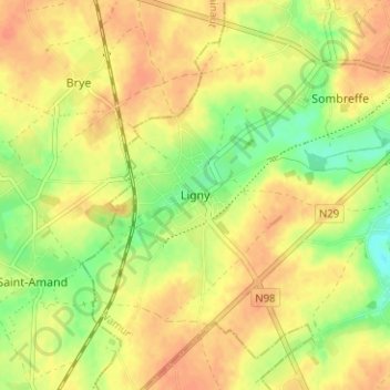
Name: Ligny topographic map, elevation, terrain.
Location: Ligny, Sombreffe, Namur, Wallonia, 5140, Belgium (50.49263 4.55576 50.53263 4.59576)
Average elevation: 147 m
Minimum elevation: 122 m
Maximum elevation: 162 m
Thank you for supporting this site ❤️
Make a donation
Make a donation
Other topographic maps
Click on a map to view its topography, its elevation and its terrain.
Thank you for supporting this site ❤️
Make a donation
Make a donation
Thank you for supporting this site ❤️
Make a donation
Make a donation