
Thank you for supporting this site ❤️
Make a donation
Make a donation
Suches topographic map
Click on the map to display elevation.
Thank you for supporting this site ❤️
Make a donation
Make a donation
About this map
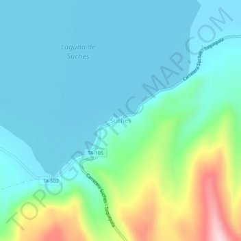
Name: Suches topographic map, elevation, terrain.
Location: Suches, Candarave, Province of Candarave, Tacna, Peru (-16.95931 -70.40804 -16.91931 -70.36804)
Average elevation: 4,520 m
Minimum elevation: 4,451 m
Maximum elevation: 4,771 m
Thank you for supporting this site ❤️
Make a donation
Make a donation
Other topographic maps
Click on a map to view its topography, its elevation and its terrain.