
Ibn Badis topographic map
Interactive map
Click on the map to display elevation.
About this map
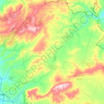
Name: Ibn Badis topographic map, elevation, terrain.
Location: Ibn Badis, Daïra Aïn Abid, Constantine, Algérie (36.24004 6.72413 36.45450 6.97410)
Average elevation: 872 m
Minimum elevation: 598 m
Maximum elevation: 1,319 m
Other topographic maps
Click on a map to view its topography, its elevation and its terrain.
Bordj M'hiris
Algérie > Constantine > Daïra Aïn Abid > Aïn Abid
Bordj M'hiris, Aïn Abid, Daïra Aïn Abid, Constantine, Algérie
Average elevation: 919 m
Douar Ali Ben Bouguera
Algérie > Constantine > Daïra Aïn Abid > Aïn Abid
Douar Ali Ben Bouguera, Aïn Abid, Daïra Aïn Abid, Constantine, Algérie
Average elevation: 900 m
Djebel El Ouahch
Algérie > Constantine > Daïra Aïn Abid > Ibn Badis
Djebel El Ouahch, Ibn Badis, Daïra Aïn Abid, Constantine, Algérie
Average elevation: 1,100 m
Mechtat Boughareb
Algérie > Constantine > Daïra Aïn Abid > Ibn Badis
Mechtat Boughareb, Ibn Badis, Daïra Aïn Abid, Constantine, Algérie
Average elevation: 1,003 m
Aïn Abid
Algérie > Constantine > Daïra Aïn Abid
Aïn Abid, Daïra Aïn Abid, Constantine, 25015, Algérie
Average elevation: 885 m