
La Condamine topographic map
Interactive map
Click on the map to display elevation.
About this map
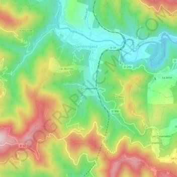
Name: La Condamine topographic map, elevation, terrain.
Average elevation: 430 m
Minimum elevation: 259 m
Maximum elevation: 670 m
Other topographic maps
Click on a map to view its topography, its elevation and its terrain.
La Besc
France > Occitanie > Gard > Chamborigaud
La Besc, Chamborigaud, Alès, Gard, Occitanie, France métropolitaine, 30530, France
Average elevation: 416 m
Les Borries
France > Occitanie > Gard > Chamborigaud
Les Borries, Chamborigaud, Alès, Gard, Occitanie, France métropolitaine, 30530, France
Average elevation: 438 m