
Thank you for supporting this site ❤️
Make a donation
Make a donation
Camurlim topographic map
Click on the map to display elevation.
Thank you for supporting this site ❤️
Make a donation
Make a donation
About this map
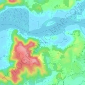
Name: Camurlim topographic map, elevation, terrain.
Location: Camurlim, Bardez, North Goa District, Goa, 403517, India (15.62466 73.78182 15.66466 73.82182)
Average elevation: 31 m
Minimum elevation: 0 m
Maximum elevation: 112 m
Thank you for supporting this site ❤️
Make a donation
Make a donation
Other topographic maps
Click on a map to view its topography, its elevation and its terrain.