Cedar Rapids topographic map
Interactive map
Click on the map to display elevation.
About this map
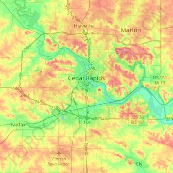
Name: Cedar Rapids topographic map, elevation, terrain.
Location: Cedar Rapids, Linn County, Iowa, United States (41.86160 -91.77458 42.06890 -91.55106)
Average elevation: 245 m
Minimum elevation: 208 m
Maximum elevation: 286 m
Other topographic maps
Click on a map to view its topography, its elevation and its terrain.
Bertram
United States > Iowa > Linn County
Bertram, Linn County, Iowa, United States
Average elevation: 232 m
Toddville
United States > Iowa > Linn County
Toddville, Linn County, Iowa, 52341, United States
Average elevation: 254 m
Marion
United States > Iowa > Linn County
Marion, Linn County, Iowa, 52302, United States
Average elevation: 256 m
Cedar Rapids
United States > Iowa > Linn County > Cedar Rapids
Cedar Rapids, Linn County, Iowa, 52401, United States
Average elevation: 249 m
Bertram
United States > Iowa > Linn County > Bertram > Bertram
Bertram, Linn County, Iowa, United States
Average elevation: 231 m
Central City
United States > Iowa > Linn County > Central City
Central City, Linn County, Iowa, 52214, United States
Average elevation: 269 m
Robins
United States > Iowa > Linn County > Robins
Robins, Linn County, Iowa, 52328, United States
Average elevation: 262 m
Palo
United States > Iowa > Linn County > Palo
Palo, Linn County, Iowa, United States
Average elevation: 229 m
Central City
United States > Iowa > Linn County
Central City, Linn County, Iowa, United States
Average elevation: 265 m
Springville
United States > Iowa > Linn County
Springville, Linn County, Iowa, 52336, United States
Average elevation: 265 m
Mount Vernon
United States > Iowa > Linn County > Mount Vernon
Mount Vernon, Linn County, Iowa, 52314, United States
Average elevation: 254 m
Hiawatha
United States > Iowa > Linn County
Hiawatha, Linn County, Iowa, 52233, United States
Average elevation: 256 m