
Thank you for supporting this site ❤️
Make a donation
Make a donation
Niedercunnersdorf topographic map
Click on the map to display elevation.
Thank you for supporting this site ❤️
Make a donation
Make a donation
About this map
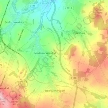
Name: Niedercunnersdorf topographic map, elevation, terrain.
Location: Niedercunnersdorf, Kottmar, Görlitz, Sachsen, Deutschland (51.02699 14.63320 51.07438 14.71735)
Average elevation: 337 m
Minimum elevation: 255 m
Maximum elevation: 438 m
Thank you for supporting this site ❤️
Make a donation
Make a donation
Other topographic maps
Click on a map to view its topography, its elevation and its terrain.
Neueibau
Deutschland > Sachsen > Görlitz > Kottmar
Neueibau befindet sich einen Kilometer südwestlich von Eibau an der S 142 zwischen Neugersdorf und Leutersdorf. Die 92 ha große Flur des Dorfes erstreckt sich beiderseits des Leutersdorfer Wassers (Leutersdorfer Bach) im Oberlausitzer Bergland. Östlich von Hetzwalde treffen sich hier der östlich gelegene,…
Average elevation: 393 m