
Thank you for supporting this site ❤️
Make a donation
Make a donation
Perundurai topographic map
Click on the map to display elevation.
Thank you for supporting this site ❤️
Make a donation
Make a donation
About this map
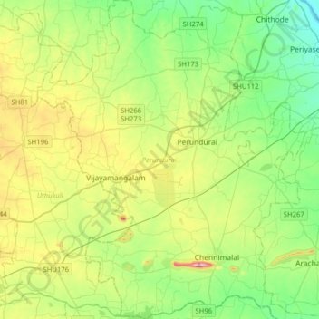
Name: Perundurai topographic map, elevation, terrain.
Location: Perundurai, Erode District, Tamil Nadu, India (11.10468 77.42546 11.41382 77.69042)
Average elevation: 264 m
Minimum elevation: 152 m
Maximum elevation: 507 m
Thank you for supporting this site ❤️
Make a donation
Make a donation
Other topographic maps
Click on a map to view its topography, its elevation and its terrain.