
Thank you for supporting this site ❤️
Make a donation
Make a donation
Fort Payne topographic map
Click on the map to display elevation.
Thank you for supporting this site ❤️
Make a donation
Make a donation
About this map
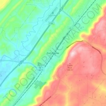
Name: Fort Payne topographic map, elevation, terrain.
Location: Fort Payne, DeKalb County, Alabama, 35967, United States (34.40425 -85.75969 34.48425 -85.67969)
Average elevation: 350 m
Minimum elevation: 238 m
Maximum elevation: 529 m
Thank you for supporting this site ❤️
Make a donation
Make a donation
Other topographic maps
Click on a map to view its topography, its elevation and its terrain.