
Make a donation
Le Plantier topographic map
Click on the map to display elevation.
Make a donation
About this map
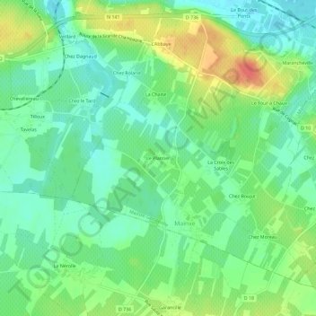
Name: Le Plantier topographic map, elevation, terrain.
Average elevation: 29 m
Minimum elevation: 10 m
Maximum elevation: 62 m
Make a donation
Other topographic maps
Click on a map to view its topography, its elevation and its terrain.
Gondeville
France > Nouvelle-Aquitaine > Charente > Mainxe-Gondeville
Le point culminant de la commune est à une altitude de 40 m, situé sur la limite sud. Le point le plus bas est à 11 m, situé le long de la Charente sur la limite ouest. Le bourg, au bord du fleuve sur sa rive gauche, est à 14 m d'altitude.
Average elevation: 22 m
Mainxe
France > Nouvelle-Aquitaine > Charente > Mainxe-Gondeville
Le territoire communal est compris dans la plaine qui s'étend entre le sud de Cognac et Bouteville. Dans la commune, cette plaine a une altitude moyenne de 30 m et est légèrement relevée au nord, avant de plonger sur la vallée de la Charente qui limite la commune au nord. Le point culminant est à une…
Average elevation: 26 m