
La Belinière topographic map
Interactive map
Click on the map to display elevation.
About this map
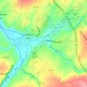
Name: La Belinière topographic map, elevation, terrain.
Average elevation: 61 m
Minimum elevation: 20 m
Maximum elevation: 122 m
Other topographic maps
Click on a map to view its topography, its elevation and its terrain.
Le Hamel
France > Normandie > Manche > Condé-sur-Vire > Les Carrières
Le Hamel, Les Carrières, Condé-sur-Vire, Saint-Lô, Manche, Normandie, France métropolitaine, 50890, France
Average elevation: 51 m
Les Carrières
France > Normandie > Manche > Condé-sur-Vire
Les Carrières, Condé-sur-Vire, Saint-Lô, Manche, Normandie, France métropolitaine, 50890, France
Average elevation: 61 m