
Make a donation
Black Fell topographic map
Click on the map to display elevation.
Make a donation
Black Fell
Black Fell is the high point in the hilly area bounded by Windermere, Langdale and Coniston. It occupies an area of around one mile by two, clad mainly in fell grass with many small outcrops of rock. Despite its modest altitude Alfred Wainwright accorded Black Fell a chapter in his Pictorial Guide to the Lakeland Fells, partly due to its excellence as a view point. It represents the perimeter of the Lakeland Fells proper in his opinion, the land to the south falling within his supplementary volume, The Outlying Fells of Lakeland. Later guidebook writers have also included Black Fell within their remit.
Make a donation
About this map
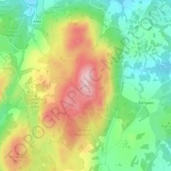
Name: Black Fell topographic map, elevation, terrain.
Average elevation: 170 m
Minimum elevation: 60 m
Maximum elevation: 320 m
Make a donation
Other topographic maps
Click on a map to view its topography, its elevation and its terrain.
Wharton Tarn
United Kingdom > England > Westmorland and Furness > Hawkshead > Hawkshead Hill
Average elevation: 173 m