
Thank you for supporting this site ❤️
Make a donation
Make a donation
Berthoud topographic map
Click on the map to display elevation.
Thank you for supporting this site ❤️
Make a donation
Make a donation
About this map
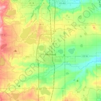
Name: Berthoud topographic map, elevation, terrain.
Location: Berthoud, Larimer County, Colorado, United States (40.27751 -105.13124 40.34932 -104.95025)
Average elevation: 1,546 m
Minimum elevation: 1,483 m
Maximum elevation: 1,635 m
Thank you for supporting this site ❤️
Make a donation
Make a donation