
South West England topographic map
Interactive map
Click on the map to display elevation.
About this map
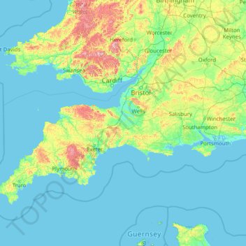
Name: South West England topographic map, elevation, terrain.
Location: South West England, United Kingdom (49.86370 -6.44581 52.11258 -1.48573)
Average elevation: 68 m
Minimum elevation: -2 m
Maximum elevation: 822 m
Inland areas of low altitude experience the least amount of precipitation. They experience the highest summer maxima temperatures, but winter minima are colder than the coast. Snowfalls are more frequent in comparison to the coast, but less so in comparison to higher ground. It experiences the lowest wind speeds and sunshine total in between that of the coast and the moors. The climate of inland areas is more noticeable the further north-east into the region.
Other topographic maps
Click on a map to view its topography, its elevation and its terrain.
London
United Kingdom > England > London
London, Greater London, England, SW1A 2DX, United Kingdom
Average elevation: 42 m
London
London, Greater London, England, United Kingdom
Average elevation: 66 m
Glasgow
United Kingdom > Scotland > Glasgow City
Glasgow, Glasgow City, Scotland, G2 1DY, United Kingdom
Average elevation: 128 m
Sheffield
Sheffield, South Yorkshire, England, United Kingdom
Average elevation: 168 m
Nottingham
United Kingdom > England > Nottinghamshire
Nottingham, England, United Kingdom
Average elevation: 56 m
Bristol
United Kingdom > England > City of Bristol
Bristol, City of Bristol, West of England, England, United Kingdom
Average elevation: 55 m
Fort William
United Kingdom > Scotland > Highland
Fort William, Highland, Scotland, PH33 6AQ, United Kingdom
Average elevation: 122 m
Peak District National Park
United Kingdom > England > Derbyshire
Peak District National Park, Derbyshire, South Yorkshire, England, United Kingdom
Average elevation: 225 m
Colchester
United Kingdom > England > Essex
Colchester, Essex, England, United Kingdom
Average elevation: 28 m
The Cotswolds National Landscape
United Kingdom > England > Gloucestershire
The Cotswolds National Landscape, Gloucestershire, West of England, England, United Kingdom
Average elevation: 109 m
Newcastle upon Tyne
Newcastle upon Tyne, North of Tyne, England, United Kingdom
Average elevation: 57 m
Hull
United Kingdom > England > Kingston upon Hull
Hull, Kingston upon Hull, England, HU1 3RJ, United Kingdom
Average elevation: 21 m
Lincolnshire
Lincolnshire, East Midlands, England, United Kingdom
Average elevation: 28 m
West Yorkshire
West Yorkshire, England, United Kingdom
Average elevation: 172 m
Cambrian Mountains
United Kingdom > Wales > Powys
Cambrian Mountains, Powys, Wales, SY18 6JR, United Kingdom
Average elevation: 319 m
West Midlands
United Kingdom > England > Warwickshire
West Midlands, Warwickshire, West Midlands Combined Authority, England, United Kingdom
Average elevation: 113 m
City of London
United Kingdom > England > City of London > City of London
City of London, England, EC2V 5AE, United Kingdom
Average elevation: 42 m
Somerset
Somerset, South West England, England, United Kingdom
Average elevation: 87 m
Aberystwyth
United Kingdom > Wales > Ceredigion
Aberystwyth, Ceredigion, Wales, SY23 1LH, United Kingdom
Average elevation: 39 m
Hastings
United Kingdom > England > East Sussex
Hastings, East Sussex, England, United Kingdom
Average elevation: 36 m
South East England
South East England, England, United Kingdom
Average elevation: 69 m
Dartmoor National Park
United Kingdom > England > Devon
Dartmoor National Park, Devon, England, United Kingdom
Average elevation: 239 m
Woking
United Kingdom > England > Surrey
Woking, Surrey, England, United Kingdom
Average elevation: 38 m
Chelmsford
United Kingdom > England > Essex
Chelmsford, Essex, England, United Kingdom
Average elevation: 54 m
Leeds
United Kingdom > England > Leeds
Leeds, Yorkshire and the Humber, England, LS1 6AL, United Kingdom
Average elevation: 94 m
Hay on Wye
United Kingdom > Wales > Powys
Hay on Wye, Powys, Wales, HR3 5AG, United Kingdom
Average elevation: 199 m
Chichester
United Kingdom > England > Chichester
Chichester, West Sussex, South East, England, United Kingdom
Average elevation: 57 m
Liverpool
Liverpool, Liverpool City Region, England, United Kingdom
Average elevation: 26 m
Birmingham
Birmingham, West Midlands Combined Authority, England, United Kingdom
Average elevation: 138 m
Lymington
United Kingdom > England > Hampshire > New Forest
Lymington, New Forest, Hampshire, England, SO41 9FP, United Kingdom
Average elevation: 15 m
Aberdeen
United Kingdom > Scotland > Aberdeen
Aberdeen, Aberdeen City, Scotland, AB11 5EQ, United Kingdom
Average elevation: 52 m
Snowdon
United Kingdom > Wales > Gwynedd
Snowdon, Gwynedd, Wales, LL55 4UL, United Kingdom
Average elevation: 692 m
Greater London
Greater London, England, United Kingdom
Average elevation: 66 m
Hampshire
Hampshire, South East, England, United Kingdom
Average elevation: 73 m
Pitlochry
United Kingdom > Scotland > Perth and Kinross
Pitlochry, Perth and Kinross, Scotland, PH16 5BX, United Kingdom
Average elevation: 276 m