Geolocate

Ios topographic map

Interactive map

Click on the map to display elevation.

About this map

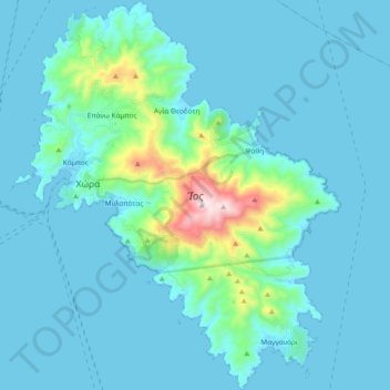
Name: Ios topographic map, elevation, terrain.

Location: Ios, Δήμος Ιητών, Thira Regional Unit, South Aegean Region, Aegean, 84001, Greece (36.64210 25.24594 36.79256 25.40308)

Average elevation: 73 m

Minimum elevation: 0 m

Maximum elevation: 718 m

The highest elevation (723 m, 2372 ft) is the Kastro (Greek: Κάστρο) peak also called Pyrgos (Greek: Πύργος), located in the center of the island, while around the Kastro are the next three Highest peaks: Xylodema (Greek: Ξυλόδεμα) (660 m, 2165 ft), Kostiza (Greek: Κοστίζα) (586 m, 1923 ft) and Prophetis Elias (Greek: Προφήτης Ηλίας) (490 m, 951 ft).

Other topographic maps

Click on a map to view its topography, its elevation and its terrain.

Icaria

Greece > Aegean > Ikaria Regional Unit

Icaria, Ikaria Regional Unit, Northern Aegean, Aegean, Greece

Average elevation: 87 m

Mykonos

Greece > Aegean > Mykonos Regional Unit > Plintri

Mykonos, Plintri, Municipality of Mykonos, Mykonos Regional Unit, South Aegean, Aegean, 846 00, Greece

Average elevation: 38 m

Kalymnos

Greece > Aegean > Kalmynos Regional Unit

Kalymnos, Kalmynos Regional Unit, South Aegean, Aegean, 852 00, Greece

Average elevation: 75 m

Santorini

Greece > Aegean > Thira Regional Unit > Thira Municipal Unit

Santorini, Thira Municipal Unit, Municipality of Thira, Thira Regional Unit, South Aegean, Aegean, Greece

Average elevation: 30 m

Naxos

Greece > Aegean > Naxos Regional Unit

Naxos, Naxos Regional Unit, South Aegean, Aegean, Greece

Average elevation: 112 m

Plintri

Greece > Aegean > Mykonos Regional Unit

Plintri, Municipality of Mykonos, Mykonos Regional Unit, South Aegean, Aegean, 846 00, Greece

Average elevation: 59 m

Vothonas

Greece > Aegean > Thira Regional Unit > Thira Municipal Unit

Vothonas, Thira Municipal Unit, Municipality of Thira, Thira Regional Unit, South Aegean, Aegean, 847 00, Greece

Average elevation: 136 m

Rhodes

Greece > Aegean

Rhodes, Aegean, Greece

Average elevation: 67 m

Kos

Greece > Aegean

Kos, Kos Regional Unit, South Aegean Region, Aegean, Greece

Average elevation: 25 m

Thira Municipal Unit

Greece > Aegean > Thira Municipal Unit

Thira Municipal Unit, Δήμος Θήρας, Thira Regional Unit, South Aegean Region, Aegean, Greece

Average elevation: 12 m

Stegna

Greece > Aegean > Stegna

Stegna, Δήμος Ρόδου, Rhodes Regional Unit, South Aegean Region, Aegean, 85102, Greece

Average elevation: 81 m

Andros

Greece > Aegean

Andros, Dimos Androu, Andros Regional Unit, South Aegean Region, Aegean, Greece

Average elevation: 83 m

Chios

Greece > Aegean > Chios Regional Unit

Chios, Chios Regional Unit, Northern Aegean, Aegean, Greece

Average elevation: 99 m

Lesbos

Greece > Aegean

Lesbos, Δήμος Λέσβου, North Aegean Region, Aegean, Greece

Average elevation: 64 m

Aegean

Greece > Aegean

Aegean, Greece

Average elevation: 124 m

Notio Aspronisi West

Greece > Aegean

Notio Aspronisi West, Δήμος Λειψών, Kalmynos Regional Unit, South Aegean Region, Aegean, Greece

Average elevation: 2 m