
Mayotte topographic map
Interactive map
Click on the map to display elevation.
About this map
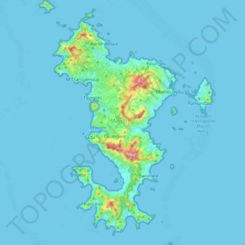
Name: Mayotte topographic map, elevation, terrain.
Location: Mayotte, Frankreich (-13.02101 45.01833 -12.63659 45.29999)
Average elevation: 27 m
Minimum elevation: 0 m
Maximum elevation: 609 m
Die Inselgruppe Mayotte besteht aus der Hauptinsel „Grande Terre“ (auch, wie das ganze Überseegebiet selbst, Mayotte genannt), der Nebeninsel „Petite Terre“ (Pamanzi) und mehreren kleineren und unbewohnten Inseln (îlots). Die Landfläche beträgt etwa 374 km². Mayotte ist mit etwa neun Millionen Jahren die älteste Vulkaninsel der Komoren. Korallenriffe umgeben die Inseln. In der Regenzeit von November bis März sind die Temperaturen höher als in der Trockenzeit. Der höchste Punkt ist mit 660 Metern der Mont Benara auf der Hauptinsel. Die Hauptstadt Mamoudzou liegt ebenfalls auf der Hauptinsel, während der internationale Flughafen Dzaoudzi Pamandzi auf Petite Terre liegt.
Other topographic maps
Click on a map to view its topography, its elevation and its terrain.
Mont Bénara
Frankreich > Mayotte > Dembéni
Mont Bénara, Dembéni, Mayotte, 97660, Frankreich
Average elevation: 328 m