
Serra d'El-Rei topographic map
Interactive map
Click on the map to display elevation.
About this map
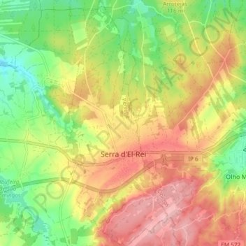
Name: Serra d'El-Rei topographic map, elevation, terrain.
Location: Serra d'El-Rei, Peniche, Leiria, Portugal (39.31102 -9.28898 39.36828 -9.25643)
Average elevation: 89 m
Minimum elevation: 14 m
Maximum elevation: 162 m
Other topographic maps
Click on a map to view its topography, its elevation and its terrain.
Reinaldes
Portugal > Leiria > Peniche > Atouguia da Baleia
Reinaldes, Atouguia da Baleia, Peniche, Leiria, 2525-246, Portugal
Average elevation: 68 m
Atouguia da Baleia
Atouguia da Baleia, Peniche, Leiria, Portugal
Average elevation: 45 m
Praia da Consolação
Praia da Consolação, Peniche, Leiria, Portugal
Average elevation: 5 m
Praia do Porto de Areia Sul
Praia do Porto de Areia Sul, Peniche, Leiria, Portugal
Average elevation: 7 m
Praia do Baleal
Praia do Baleal, Peniche, Leiria, Portugal
Average elevation: 5 m