
Thank you for supporting this site ❤️
Make a donation
Make a donation
Wister topographic map
Click on the map to display elevation.
Thank you for supporting this site ❤️
Make a donation
Make a donation
About this map
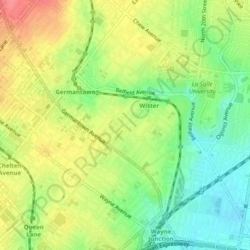
Name: Wister topographic map, elevation, terrain.
Average elevation: 66 m
Minimum elevation: 32 m
Maximum elevation: 103 m
Thank you for supporting this site ❤️
Make a donation
Make a donation
Other topographic maps
Click on a map to view its topography, its elevation and its terrain.
Philadelphia
United States > Pennsylvania > Philadelphia County > Philadelphia
Average elevation: 35 m
Franklin Delano Roosevelt Park
United States > Pennsylvania > Philadelphia County > Philadelphia
Average elevation: 5 m
Aviv's Garden
United States > Pennsylvania > Philadelphia County > Philadelphia
Average elevation: 15 m
Thank you for supporting this site ❤️
Make a donation
Make a donation