
Make a donation
Liberty Lake topographic map
Click on the map to display elevation.
Make a donation
Liberty Lake
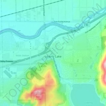
Areas east of Liberty Lake Road and areas north of Appleway Road lie on the relatively flat land along the floor of the Spokane Valley. Elevations there range from between 2,000 feet above sea level at the river to around 2,150 feet around Liberty Lake Elementary School. The areas west of Liberty Lake Road and south of Appleway Road show far more topographical relief, rising from around 2,100 feet to over 2,600 feet on Carlson Hill. Kramer Hill, which rises just beyond the eastern limit of the city, quickly rises to above 2,700 feet. While Mica Peak, which rises beyond the southern shore of the lake, climbs to nearly 5,100 feet.
Make a donation
About this map
Name: Liberty Lake topographic map, elevation, terrain.
Average elevation: 644 m
Minimum elevation: 603 m
Maximum elevation: 816 m
Make a donation