
Thank you for supporting this site ❤️
Make a donation
Make a donation
Rowe topographic map
Click on the map to display elevation.
Thank you for supporting this site ❤️
Make a donation
Make a donation
About this map
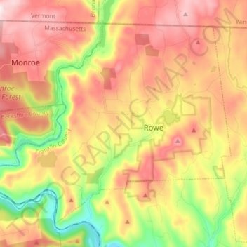
Name: Rowe topographic map, elevation, terrain.
Location: Rowe, Franklin County, Massachusetts, 01367, United States (42.65451 -72.99576 42.73911 -72.85403)
Average elevation: 463 m
Minimum elevation: 181 m
Maximum elevation: 672 m
Thank you for supporting this site ❤️
Make a donation
Make a donation
Other topographic maps
Click on a map to view its topography, its elevation and its terrain.
North Sunderland
United States > Massachusetts > Franklin County > Sunderland
Average elevation: 100 m
Thank you for supporting this site ❤️
Make a donation
Make a donation
Thank you for supporting this site ❤️
Make a donation
Make a donation