
Thank you for supporting this site ❤️
Make a donation
Make a donation
Al Dhannah topographic map
Click on the map to display elevation.
Thank you for supporting this site ❤️
Make a donation
Make a donation
About this map
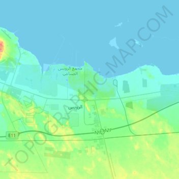
Name: Al Dhannah topographic map, elevation, terrain.
Average elevation: 14 m
Minimum elevation: -3 m
Maximum elevation: 100 m
Thank you for supporting this site ❤️
Make a donation
Make a donation
Other topographic maps
Click on a map to view its topography, its elevation and its terrain.
Zarkoh Island
United Arab Emirates > Abu Dhabi Emirate > Al Dhafrah Region > Zirku Island
Average elevation: 10 m
Thank you for supporting this site ❤️
Make a donation
Make a donation
Thank you for supporting this site ❤️
Make a donation
Make a donation
Al Ruwais
United Arab Emirates > Abu Dhabi Emirate > Al Dhafrah Region > Al Ruways Industrial City
Average elevation: 16 m