
Make a donation
Klotten topographic map
Click on the map to display elevation.
Make a donation
Klotten
Auf einer Bergkuppe über Klotten liegt Burg Coraidelstein. In der Nähe auf den Moselhöhen befindet sich der Wild- und Freizeitpark Klotten. Sehenswert sind die am Moselhöhenweg liegende Seitskapelle und das Naturschutzgebiet Dortebachtal.
Make a donation
About this map
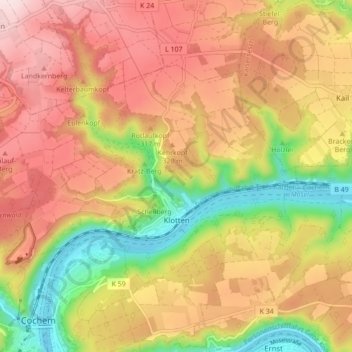
Name: Klotten topographic map, elevation, terrain.
Average elevation: 273 m
Minimum elevation: 78 m
Maximum elevation: 434 m
Make a donation
Other topographic maps
Click on a map to view its topography, its elevation and its terrain.
Löffelscheid
Deutschland > Rheinland-Pfalz > Landkreis Cochem-Zell
Die festliche Einweihung der neuen Filialkirche in Löffelscheid „Maria Heimsuchung“ fand am 5. Juli 1964 statt. Patronin ist die Mutter Gottes („Maria Heimsuchung“), zweiter Patron ist der Heilige Nikolaus. Die Kirche ist ein Rundbau (zwei Kegel wurden ineinandergeschoben). Der Architekt war Bruno…
Average elevation: 439 m
Make a donation
Müdener Bock
Deutschland > Rheinland-Pfalz > Landkreis Cochem-Zell > Müden (Mosel)
Average elevation: 244 m
Make a donation