
Thank you for supporting this site ❤️
Make a donation
Make a donation
Murtas topographic map
Click on the map to display elevation.
Thank you for supporting this site ❤️
Make a donation
Make a donation
About this map
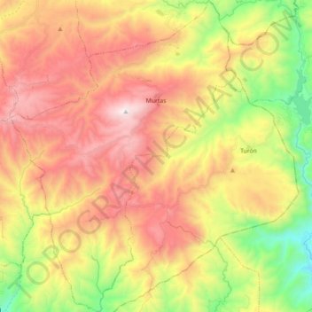
Name: Murtas topographic map, elevation, terrain.
Average elevation: 823 m
Minimum elevation: 128 m
Maximum elevation: 1,504 m
Thank you for supporting this site ❤️
Make a donation
Make a donation
Other topographic maps
Click on a map to view its topography, its elevation and its terrain.
Yegen
Spanje > Andalusië > Comarca de la Alpujarra Granadina > Alpujarra de la Sierra
Average elevation: 1,054 m
Sierra Nevada
Spanje > Andalusië > Comarca de la Alpujarra Granadina > Lanjarón
Average elevation: 2,223 m