
Thank you for supporting this site ❤️
Make a donation
Make a donation
San Rafael topographic map
Click on the map to display elevation.
Thank you for supporting this site ❤️
Make a donation
Make a donation
About this map
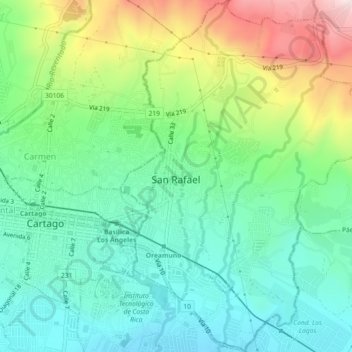
Name: San Rafael topographic map, elevation, terrain.
Location: San Rafael, Cantón de Oreamuno, Cartago, 30701, Costa Rica (9.84783 -83.91076 9.89251 -83.87950)
Average elevation: 1,501 m
Minimum elevation: 1,346 m
Maximum elevation: 1,839 m
Thank you for supporting this site ❤️
Make a donation
Make a donation
Other topographic maps
Click on a map to view its topography, its elevation and its terrain.