
Les Jobarts topographic map
Interactive map
Click on the map to display elevation.
About this map
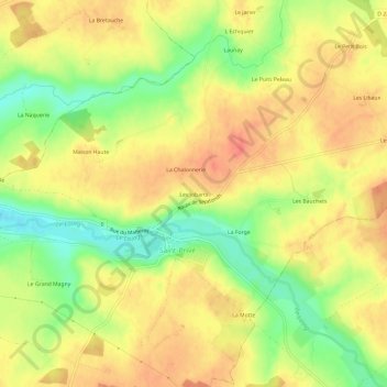
Name: Les Jobarts topographic map, elevation, terrain.
Average elevation: 194 m
Minimum elevation: 161 m
Maximum elevation: 215 m
Other topographic maps
Click on a map to view its topography, its elevation and its terrain.
Les Champs des Creux Bas
France > Bourgogne-Franche-Comté > Yonne > Saint-Privé > L Echiquier
Les Champs des Creux Bas, L Echiquier, Saint-Privé, Auxerre, Yonne, Bourgogne-Franche-Comté, France métropolitaine, 89220, France
Average elevation: 199 m