
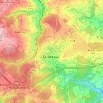
Kaisersesch topographic map
Interactive map
Click on the map to display elevation.
About this map
Name: Kaisersesch topographic map, elevation, terrain.
Average elevation: 451 m
Minimum elevation: 334 m
Maximum elevation: 548 m
Other topographic maps
Click on a map to view its topography, its elevation and its terrain.
Treis-Karden
Deutschland > Rheinland-Pfalz > Landkreis Cochem-Zell
Treis-Karden, Cochem, Landkreis Cochem-Zell, Rheinland-Pfalz, 56253, Deutschland
Average elevation: 241 m
Zell (Mosel)
Deutschland > Rheinland-Pfalz > Landkreis Cochem-Zell
Zell (Mosel), Landkreis Cochem-Zell, Rheinland-Pfalz, 56856, Deutschland
Average elevation: 287 m
Cochem
Deutschland > Rheinland-Pfalz > Landkreis Cochem-Zell
Cochem, Landkreis Cochem-Zell, Rheinland-Pfalz, Deutschland
Average elevation: 286 m
Beilstein
Deutschland > Rheinland-Pfalz > Landkreis Cochem-Zell > Beilstein
Beilstein, Cochem, Landkreis Cochem-Zell, Rheinland-Pfalz, Deutschland
Average elevation: 239 m