
Make a donation
Hebron topographic map
Click on the map to display elevation.
Make a donation
About this map
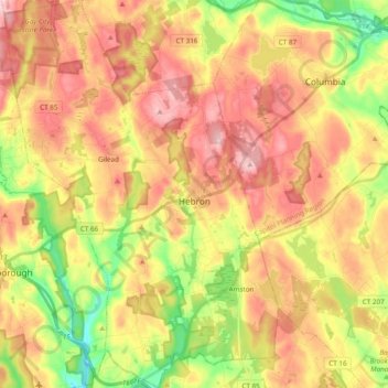
Name: Hebron topographic map, elevation, terrain.
Location: Hebron, Capitol Planning Region, Connecticut, United States (41.58870 -72.46022 41.73197 -72.32436)
Average elevation: 154 m
Minimum elevation: 53 m
Maximum elevation: 240 m
Make a donation
Other topographic maps
Click on a map to view its topography, its elevation and its terrain.
Suffield Depot
United States > Connecticut > Capitol Planning Region > Suffield
Average elevation: 42 m
South Glastonbury
United States > Connecticut > Capitol Planning Region > Glastonbury
Average elevation: 48 m
East Windsor Hill
United States > Connecticut > Capitol Planning Region > South Windsor
Average elevation: 16 m
Make a donation
Hockanum
United States > Connecticut > Capitol Planning Region > East Hartford
Average elevation: 11 m
Glastonbury Center
United States > Connecticut > Capitol Planning Region > Glastonbury
Average elevation: 27 m
Make a donation
Wormwood Hill
United States > Connecticut > Capitol Planning Region > Mansfield
Average elevation: 163 m
Whitings Corner
United States > Connecticut > Capitol Planning Region > West Hartford
Average elevation: 84 m
Mansfield City
United States > Connecticut > Capitol Planning Region > Mansfield
Average elevation: 147 m
Make a donation
Stafford Springs
United States > Connecticut > Capitol Planning Region > Stafford
Average elevation: 200 m
Silvermine Acres
United States > Connecticut > Capitol Planning Region > Canton
Average elevation: 150 m
Wickham Park
United States > Connecticut > Capitol Planning Region > Manchester
Average elevation: 40 m
Make a donation
Staffordville
United States > Connecticut > Capitol Planning Region > Stafford
Average elevation: 251 m
Halladay Corner
United States > Connecticut > Capitol Planning Region > Suffield
Average elevation: 42 m