
Town of Chazy topographic map
Interactive map
Click on the map to display elevation.
About this map
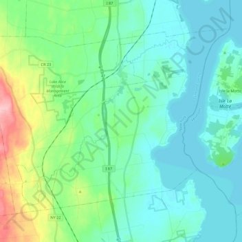
Name: Town of Chazy topographic map, elevation, terrain.
Location: Town of Chazy, Clinton County, New York, United States (44.79948 -73.55496 44.91694 -73.33933)
Average elevation: 57 m
Minimum elevation: 27 m
Maximum elevation: 173 m
Other topographic maps
Click on a map to view its topography, its elevation and its terrain.
Lyon Mountain
United States > New York > Clinton County > Town of Saranac
Lyon Mountain, Town of Saranac, Clinton County, New York, United States
Average elevation: 951 m
Coopersville
United States > New York > Clinton County > Town of Champlain
Coopersville, Town of Champlain, Clinton County, New York, 12919, United States
Average elevation: 39 m
Davis Lake
United States > New York > Clinton County > Town of Peru
Davis Lake, Town of Peru, Clinton County, New York, 12985, United States
Average elevation: 204 m
Ausable Chasm
United States > New York > Clinton County
Ausable Chasm, Town of AuSable, Clinton County, New York, 12911, United States
Average elevation: 117 m