
Thank you for supporting this site ❤️
Make a donation
Make a donation
Cedar Island topographic map
Click on the map to display elevation.
Thank you for supporting this site ❤️
Make a donation
Make a donation
About this map
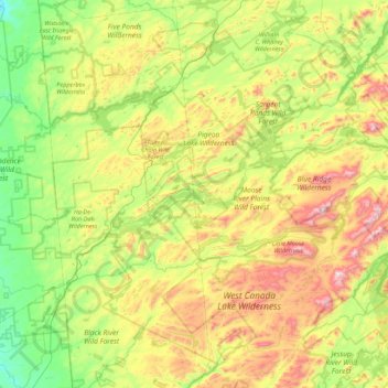
Name: Cedar Island topographic map, elevation, terrain.
Average elevation: 589 m
Minimum elevation: 303 m
Maximum elevation: 1,158 m
Thank you for supporting this site ❤️
Make a donation
Make a donation
Other topographic maps
Click on a map to view its topography, its elevation and its terrain.
Brown Tract Pond Campground
United States > New York > Hamilton County > Town of Inlet
Average elevation: 564 m