
River aux Vases topographic map
Interactive map
Click on the map to display elevation.
About this map
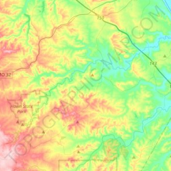
Name: River aux Vases topographic map, elevation, terrain.
Average elevation: 198 m
Minimum elevation: 111 m
Maximum elevation: 332 m
Other topographic maps
Click on a map to view its topography, its elevation and its terrain.
Clearwater
United States > Missouri > Sainte Genevieve County
Clearwater, Sainte Genevieve County, Missouri, United States
Average elevation: 195 m
St. Mary
United States > Missouri > Sainte Genevieve County > St. Mary
St. Mary, Sainte Genevieve County, Missouri, United States
Average elevation: 135 m