
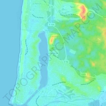
Lo Rey du Lac topographic map
Interactive map
Click on the map to display elevation.
About this map
Name: Lo Rey du Lac topographic map, elevation, terrain.
Average elevation: 9 m
Minimum elevation: -3 m
Maximum elevation: 46 m
Other topographic maps
Click on a map to view its topography, its elevation and its terrain.
Port de Capbreton
France > Nouvelle-Aquitaine > Landes > Soorts-Hossegor
Port de Capbreton, Soorts-Hossegor, Arrondissement de Dax, Landes, Nouvelle-Aquitaine, France métropolitaine, 40130, France
Average elevation: 5 m
Port de Capbreton
France > Nouvelle-Aquitaine > Landes > Soorts-Hossegor
Port de Capbreton, Soorts-Hossegor, Arrondissement de Dax, Landes, Nouvelle-Aquitaine, France métropolitaine, 40130, France
Average elevation: 5 m
Labrannère
France > Nouvelle-Aquitaine > Landes > Soorts-Hossegor
Labrannère, Soorts-Hossegor, Arrondissement de Dax, Landes, Nouvelle-Aquitaine, France métropolitaine, 40150, France
Average elevation: 10 m