
Thank you for supporting this site ❤️
Make a donation
Make a donation
Ringwood topographic map
Click on the map to display elevation.
Thank you for supporting this site ❤️
Make a donation
Make a donation
About this map
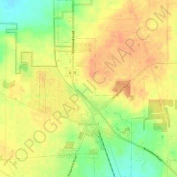
Name: Ringwood topographic map, elevation, terrain.
Location: Ringwood, McHenry County, Illinois, United States (42.38216 -88.32243 42.41561 -88.28599)
Average elevation: 263 m
Minimum elevation: 237 m
Maximum elevation: 278 m
Thank you for supporting this site ❤️
Make a donation
Make a donation
Other topographic maps
Click on a map to view its topography, its elevation and its terrain.
Elizabeth Lake Nature Preserve
United States > Illinois > McHenry County > Twin Lakes
Average elevation: 250 m
Thank you for supporting this site ❤️
Make a donation
Make a donation