
Make a donation
St. Clair topographic map
Click on the map to display elevation.
Make a donation
About this map
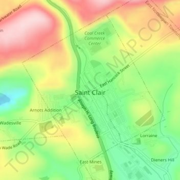
Name: St. Clair topographic map, elevation, terrain.
Average elevation: 271 m
Minimum elevation: 151 m
Maximum elevation: 401 m
Make a donation
Other topographic maps
Click on a map to view its topography, its elevation and its terrain.
Zion Grove
United States > Pennsylvania > Schuylkill County > North Union Township
Average elevation: 323 m
Bear Ridge
United States > Pennsylvania > Schuylkill County > West Mahanoy Township
Average elevation: 389 m
Rough and Ready
United States > Pennsylvania > Schuylkill County > Upper Mahantango Township
Average elevation: 234 m
Make a donation
Jefferson
United States > Pennsylvania > Schuylkill County > South Manheim Township
Average elevation: 215 m
Blue Mountain
United States > Pennsylvania > Schuylkill County > West Penn Township
The ridge of Blue Mountain runs for 150 miles (240 km) through Pennsylvania, reaching an elevation of 2,270 feet (690 m) above sea level just north of the Pennsylvania Turnpike, near the borough of Newburg. Most of the ridgecrest, however, only reaches between 1,400 and 1,700 feet (430 and 520 m) in elevation.…
Average elevation: 251 m
Helfenstein
United States > Pennsylvania > Schuylkill County > Butler Township
Average elevation: 388 m
Make a donation
Newton Junction
United States > Pennsylvania > Schuylkill County > Mahanoy Township
Average elevation: 459 m
Lincoln
United States > Pennsylvania > Schuylkill County > Tremont Township > Lincoln
Average elevation: 407 m
Lower Brownsville
United States > Pennsylvania > Schuylkill County > West Mahanoy Township
Average elevation: 425 m