
Thank you for supporting this site ❤️
Make a donation
Make a donation
Mehla topographic map
Click on the map to display elevation.
Thank you for supporting this site ❤️
Make a donation
Make a donation
About this map
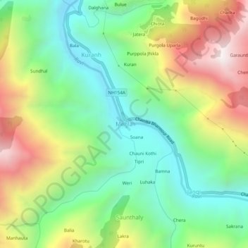
Name: Mehla topographic map, elevation, terrain.
Location: Mehla, Chamba, Himachal Pradesh, India (32.46461 76.15771 32.50461 76.19771)
Average elevation: 1,469 m
Minimum elevation: 956 m
Maximum elevation: 2,288 m
Thank you for supporting this site ❤️
Make a donation
Make a donation