
Thank you for supporting this site ❤️
Make a donation
Make a donation
Serra de Arga topographic map
Click on the map to display elevation.
Thank you for supporting this site ❤️
Make a donation
Make a donation
About this map
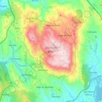
Name: Serra de Arga topographic map, elevation, terrain.
Location: Serra de Arga, Viana do Castelo, Portugal (41.77505 -8.83835 41.85238 -8.67559)
Average elevation: 292 m
Minimum elevation: 2 m
Maximum elevation: 823 m
Thank you for supporting this site ❤️
Make a donation
Make a donation
Other topographic maps
Click on a map to view its topography, its elevation and its terrain.