
炎陵县 topographic map
Interactive map
Click on the map to display elevation.
About this map
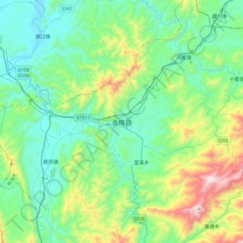
Name: 炎陵县 topographic map, elevation, terrain.
Location: 炎陵县, 株洲市, 湖南省, 中国 (26.33301 113.60812 26.65301 113.92812)
Average elevation: 465 m
Minimum elevation: 129 m
Maximum elevation: 1,594 m
周边相邻县市有,东接江西井冈山市和遂川县,南临本省桂东县,西界资兴市、永兴县和安仁县,北与茶陵县相连。炎陵为湖南重要林业县,有大院冷杉(资源冷杉)。传说炎帝神农氏崩葬于境内鹿原陂,故于1994年4月5日更名炎陵。主要旅游景点有炎帝陵和神农谷国家森林公园,还有湖南第一峰-神农峰(海拔2115.2m)。
Other topographic maps
Click on a map to view its topography, its elevation and its terrain.