Geolocate

Spirit Lake topographic map

Interactive map

Click on the map to display elevation.

About this map

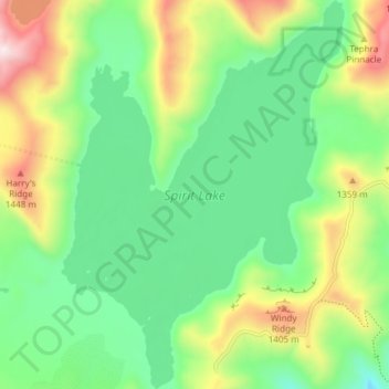
Name: Spirit Lake topographic map, elevation, terrain.

Location: Spirit Lake, Skamania County, Washington, United States (46.24663 -122.16614 46.29837 -122.11151)

Average elevation: 1,144 m

Minimum elevation: 905 m

Maximum elevation: 1,609 m

Prior to 1980, Spirit Lake consisted of two arms that occupied what had been the valleys of the North Fork Toutle River and a tributary. About 4,000 years ago, these valleys were blocked by lahars and pyroclastic flow deposits from Mount St. Helens to form the pre-1980 Spirit Lake. The longest branch of Spirit Lake was about 2.1 miles (3.4 km) long. A stable outlet channel flowed from the lake to the North Fork Toutle River across a natural dam composed of volcanic material. The level of Spirit Lake remained basically stable, at an altitude of about 3,198 ft (970 m).[2][6][7]

Other topographic maps

Click on a map to view its topography, its elevation and its terrain.

Mount Saint Helens

United States > Washington > Skamania County

Mount Saint Helens, Skamania County, Washington, United States

Average elevation: 2,096 m

Camp Kwoneesum Dam

United States > Washington > Skamania County

Camp Kwoneesum Dam, Skamania County, Washington, United States

Average elevation: 343 m

Northwoods

United States > Washington > Skamania County

Northwoods, Skamania County, Washington, United States

Average elevation: 447 m

Underwood

United States > Washington > Skamania County

Underwood, Skamania County, Washington, 98605, United States

Average elevation: 116 m

Sleeping Beauty

United States > Washington > Skamania County

Sleeping Beauty, Skamania County, Washington, United States

Average elevation: 1,179 m

Lake Bonneville

United States > Washington > Skamania County

Lake Bonneville, Skamania County, Washington, 98639, United States

Average elevation: 82 m

Indian Heaven Wilderness

United States > Washington > Skamania County

Indian Heaven Wilderness, Skamania County, Washington, United States

Average elevation: 1,191 m

Lava Dome

United States > Washington > Skamania County

Lava Dome, Skamania County, Washington, United States

Average elevation: 2,109 m

Skamania

United States > Washington > Skamania County

Skamania, Skamania County, Washington, 97014, United States

Average elevation: 59 m

North Bonneville

United States > Washington > Skamania County > North Bonneville

North Bonneville, Skamania County, Washington, 98639, United States

Average elevation: 201 m

Stevenson

United States > Washington > Skamania County

Stevenson, Skamania County, Washington, 98648, United States

Average elevation: 75 m

Carson

United States > Washington > Skamania County > Carson

Carson, Skamania County, Washington, 98610, United States

Average elevation: 229 m

Sunset Falls

United States > Washington > Skamania County

Sunset Falls, Skamania County, Washington, United States

Average elevation: 457 m

Beacon Rock

United States > Washington > Skamania County

Beacon Rock, Skamania County, Washington, 97014, United States

Average elevation: 93 m

Mount Saint Helens National Volcanic Monument

United States > Washington > Skamania County

Mount Saint Helens National Volcanic Monument, Skamania County, Washington, United States

Average elevation: 896 m